
Meest populaire keuze

Amazon.be· Bekende aanbieder
€ 8,25
3 tot 4 dagenGratis verzending
Check de website voor de levertijd | Gratis bezorgd > €20,-


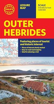
Brand new edition of this easy-to-use Philip's sheet map of the Outer Hebrides, giving detailed coverage of the area's road network, and featuring all the major places of tourist and historic interest.
The latest edition of this information-packed Philip's leisure map of the Outer Hebrides (or Western Isles) gives clear and detailed coverage of the archipelago's road networks at a scale of 3.16 miles to 1 inch. From the bustle of Stornoway to the flora and fauna of the remotest spots, this is the only companion you will need.
The easy-to-use map shows all the major places of tourist and historic interest, including ancient sites, beaches, castles, camping sites, country parks, galleries, gardens, golf courses, museums, nature trails and walks, standing stones, sports and entertainment venues. Whether bracing sea walks, learning Scottish Gaelic or savouring distilleries is your plan, a handy index makes them all easy to find and enjoy.
Local or a visitor, the convenient, single-sided sheet map is ideally suited for leisure and business use.
Heb jij dit product in bezit en wil je graag je mening geven? Start dan hieronder met het schrijven van je review. Afhankelijk van de details duurt het schrijven van een review gemiddeld tussen de 3 en 10 minuten. Met jouw mening help je andere bezoekers een betere keuze te maken én maak je iedere maand kans op €250,-! Klik hier voor de actievoorwaarden.
